Coast to Coast – Late Portuguese Infrastructural Development in Continental África (Angola and Mozambique): Critical and Historical Analysis and Postcolonial Assessment
Based on the survey, cataloguing and contextualization of the infrastructural process of the former Portuguese colonial territory in continental Africa (Angola and Mozambique) in the last century of Portuguese colonization (1875-1975), the research aims at analyzing the influence of colonial strategies on the current developments in these two countries.
The research is based on the thesis that colonial territorial infrastructure processes leave resilient marks in the post-colonial built landscape, whose impact must be analyzed in order to support future actions.
Critical analysis of these infrastructures in the postcolonial period will contribute to cross-readings with the research of the African scientific community.
ISCTE-IUL
FCG (PT)
UEM (MZ)
UTANGA (AO)
(1952) [PT/AHU/OP5202]

Summary
The research is based on the thesis that colonial territorial infrastructure processes leave resilient marks in the post-colonial built landscape, whose impact must be analyzed in order to support future actions.
The project will be undertaken through two phases:
1) analysis of the infrastructure process from the mapping of three specific typologies of colonial public works (described below), which will be approached from the perspective of archival and documentary analysis, cartography and historiographic description;
2) identification and critical analysis of the state of these infrastructures (reuse, reinforcement or abandonment) after independence in 1975.
Three programmatic typologies are considered to be decisive in territorial occupation and are still visible today:
(i) transport networks (highways, ports, railways and airports);
(ii) production of hydroelectric energy (dams and facilities);
(iii) settlements associated with the exploitation of natural resources (mining and agriculture). The three programs are significantly interrelated, reproducing the Portuguese centralizing model of colonial exploration.
The data obtained in the first phase of the project will be used to describe the main investment policies in these three programs, to verify their degree of achievement and the technical means involved (focusing on the areas of Architecture and Engineering).
An in-depth knowledge of the dynamics of colonization from the perspective of Architecture, occupation, exploration and construction of the African territory requires new approaches: the extension of chronological periods analysed (currently dominated only by the study of the Modern Movement), thus including colonial policies resulting from different governments (late constitutional monarchy, first republic and dictatorship); and the analysis of the architectural object within a network (and not as an exceptional work).
Analyzing the pre-independence history of Angola and Mozambique in parallel results from: 1) the historical process of the Pink Map (‘Mapa Cor-de-Rosa’), reflecting the ambition to occupy a territorial strip from the Atlantic to the Indian (Coast to Coast); 2) the centralizing vision of Portuguese colonial management (unlike other European powers). The chronological spectrum of the research was established with the creation of the Sociedade de Geografia de Lisboa (SGL) in 1875, demonstrating an important change in Portuguese colonial policies, and updating them in the scientific and physical knowledge of the African territory, along with the other European powers.
The analysis of this fact will break with the current state of the art. The ‘Arquivo Histórico Ultramarino’ has a fundamental part of the documentary nucleus related to the colonial public works of the 19th and 20th centuries. Its archival treatment, cataloguing and description will be undertaken within the project, making the fund accessible to the scientific community (which currently does not happen).
The ‘Projectos e Obras’ fund of the Calouste Gulbenkian Foundation will also be consulted, which remains unpublished and also requires an appropriate archival description, which this project will also ensure. Both institutions are partners of the project.
The team is made up of Portuguese, Angolan and Mozambican researchers, architects, historians and archivists. External University Institutions – ‘Universidade Técnica de Angola’ and ‘Universidade Eduardo Mondlane’ – assure, in the first phase, support to the consultations to the local archives and part of the fieldwork, playing a fundamental role in the second phase that evaluates the resilience, transformation and adaptation of the existing colonial infrastructures.
The researchers will be assisted by the team of consultants that guarantees a fundamental part of the objectives:
(i) experience of infrastructures project in the colonial period (José Quinhones Levi);
(ii) comparative studies (Johan Lagae, former Belgian Congo, Charles Jenkins, South Africa);
(iii) support for fieldwork and post-colonial analysis (Isabel Martins in Angola, José Forjaz in Mozambique). After the mapping of the three programs, with the support of specialized cartography, documentation will be collected and case studies will be selected, based on specific criteria (strategic relevance, scale, repercussion on the constructed landscape). This is followed by a detailed and historical description with a view to the creation of inventory records in the HPIP of the FCG and to their reference in GIS, accompanied by the verification of the state of conservation and the survey of the post-independence interventions.
Team


Ana Canas Delgado Martins
RESEARCHER


António Deus
Researcher


Elisiário Miranda
RESEARCHER


Jéssica Lage
Researcher

João Vieira
Researcher

Jorge Figueira
Researcher
José Luís Saldanha
Researcher

Juliana Guedes
Researcher

Luis Lage
Researcher

Maria Manuela Portugal
Researcher


Paulo Tormenta Pinto
Researcher

Rogério Vieira de Almeida
Researcher


Walter Rossa
Researcher
Idalina Nunes (BI)
Researcher
Results
BOOK CHAPTERS
FIÚZA, Filipa; MILHEIRO, Ana Vaz (2019). Colonizing and infrastructuring the Angolan territory through colonist settlements: the case of the Cela Settlement, in Carlos Nunes Silva (ed). Routledge Handbook of Urban Planning in Africa. London/New York: Routledge, p. 90-106.
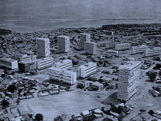
MILHEIRO, Ana Vaz (forthcoming 2020). “Luanda: modernization and colonization at the origins of an African mega-city”, Rukumana, Deden, Planning Megacities in the Global South, Routledge. Release: Summer 2020.
MILHEIRO, Ana Vaz (2019). “África Colonial: Arquitectura e infraestruturas nos últimos anos do Estado Novo”, in J. Brites; L.M. Correia (coord.), Obras Públicas no Estado Novo. Coimbra: Imprensa da Universidade de Coimbra (ISBN 978-989-26-1824-1 – Impresso / 978-989-26-1894-4 – Digital).
MILHEIRO, Ana Vaz (2019). “Former “Portuguese” Sub-Saharan colonial Africa: a drawing narrative”. Pedro Antonio Janeiro (ed.) Drawing (…) City (…) Body, Dwelling on Earth, London: CRC Press – Taylor & Francis Group, p. 15-19 (ISBN 9780429398773). Link
SERRAZINA, Beatriz; MILHEIRO, Ana Vaz (2019). “Diamang’s urban project: between the Peace of Versailles and the Colonial Act” in Carlos Nunes Silva (ed). Routledge Handbook of Urban Planning in Africa. London/New York: Routledge, p. 107-122.
SPECIAL ISSUE
PACHECO, Mónica (editor, 2017). “Global Practices, Transnational Pedagogies”, Charrette, Journal of the Association of Architectural Educators, 4(2) autumn 2017 (ISSN 2054-6718). Link
ARTICLES
MARTINS, Ana Canas Delgado (2019). “Nós, os outros e os arquivos na construção de identidades”, in Pesq. Bras. em Ci. da Inf. e Bib., João Pessoa, v. 14, n. 3, p. 42-47 (ISSN: 1981-0695).
MILHEIRO, Ana Vaz; FIÚZA, Filipa (submitted 2020). “Women architects in Portugal: working in colonial Africa before the Carnation Revolution (1950-1974)”, Arts (ISSN 2076- 0752). 38
MILHEIRO, Ana Vaz (submitted 2019). “Late Portuguese colonialism in Africa: the role of the Agência Geral do Ultramar”, RIBA Journal magazine.
MILHEIRO, Ana Vaz (submitted 2019). “Colonial Landscapes: Cities and Infrastructures in former Portuguese Southern African colonies- A brief historiographical analysis based on the colonial transport networks”, Journal African Geographical Review. [submitted to peer review]
PINTO, Paulo Tormenta; MILHEIRO, Ana Vaz; MIRANDA, Elisiário; PINTO, Pedro (submitted 2019). “From Monumentality to Diversity – Lourenço Marques between the urban plans of Aguiar and Azevedo (1950-1970)”, Carola Hein (Ed.), Planning Perspectives. [reviewed and submitted January 2020]
SALDANHA, José Luís Possolo de (2018). “De São Paulo de Luanda a São Paulo de Macau: Fundação e consolidação de duas cidades quinhentistas no Ultramar Português”, Revista Cidades Comunidades e Territórios, n.36, Junho, DINÂMIA-CET’IUL, p. 1-18 (ISSN: 2182- 3030).
SALDANHA, José Luís Possolo de (2018). “Luís Possolo, el estudiante portugués en la edición inaugural del Curso en Arquitectura Tropical de la Architectural Assocation”, in Revista “rita_ redfundamentos”, n.9, May, p. 81-89. (ISSN: 2340-9711 (print); 2386-7027 (online) link
SALDANHA, José Luís Possolo de (2023). “Edgar Cardoso’s bridge at Quiamafulo, Angola. Design and construction in the late 1950’s of the third road viaduct across the River Cuanza”, in Construction History, n. 38(1), p.49-71. (ISSN: 0267-7768 (print); 0267-7768 (online) link